

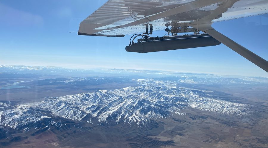
Collection planning for any remote sensing mission is a crucial step in collecting relevant and timely data. To develop a successful radar data collection plan, mission specialists need to perform a terrain and mission analysis, understand radar geometry, and know the capabilities of their radar system and the platform they will use for collection.
To optimize their results, radar operators need to perform a pre-mission analysis before they begin directing an aircraft and sensor to collect data. An analysis should consider the following factors:
Terrain Masking: In a pre-mission analysis, the possibility of terrain masking is an important consideration. The terrain of an area can hide, or mask, objects of interest, depending on the angle at which the data is collected. If radar energy does not reach a particular area due to terrain masking, no CCD products will be collected because the area neither receives nor returns any radar energy. Operators should look at the collection area first before making a flight plan, so terrain masking is minimized or mitigated completely by collecting at the right geometry.
When planning for a data collection, operators need to consider the angle at which the radar is transmitting to the surface being scanned. The optimal angle depends on the desired radar mode. For example, for high-detailed SAR collection, a steeper grazing angle might be optimal, but for MTI and broad coverage SAR, a shallower grazing angle is typically desired.
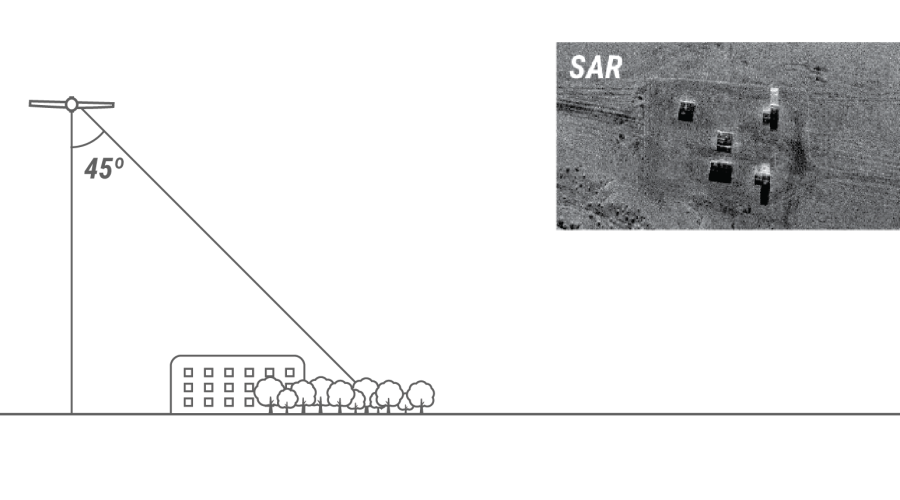
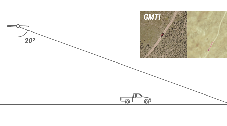
For more information on the relevant angles involved in airborne SAR collection, see Interpreting Radar Imagery.
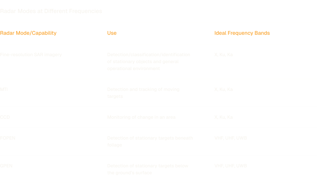
Aligning the goals of the ISR mission with the capabilities of the radar is essential. Different radar modes allow for different types of data intelligence. Also, different frequency bands are capable of gathering different types of information.
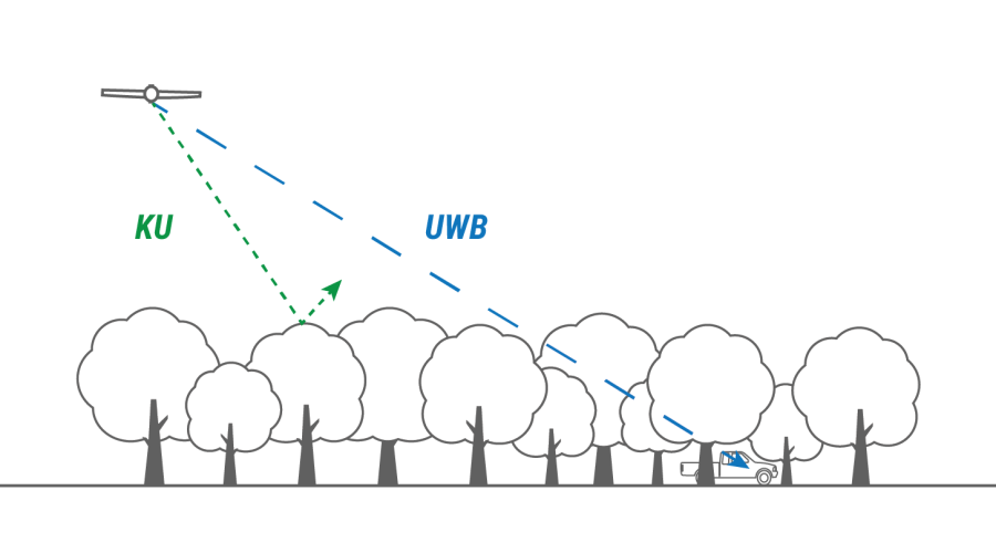
Radar is most sensitive to objects that are larger than the wavelength of the transmitted signal and is mostly unaffected by relatively smaller particles. Radars operating at lower frequency bands have longer wavelengths and may achieve some degree of ground penetration (GPEN) or foliage penetration (FOPEN). For example, an Ultra Wide Band (UWB) radar system, which spans between the UHF and L bands (with wavelengths between 15 cm to 1 m), will provide better GPEN and FOPEN properties than radars with shorter wavelengths at higher frequency bands, such as Ku-band with a wavelength of about 1.6-2.0 cm. However, the shorter wavelength and higher frequency bands are generally better for making clearer images of smaller objects and features, which can lead to better target classification, tracking, and change detection.
For more information on radar frequencies, see Radar Characteristics in Interpreting Radar Imagery.
For more information on IMSAR radar capabilities, see Multimode Capability.
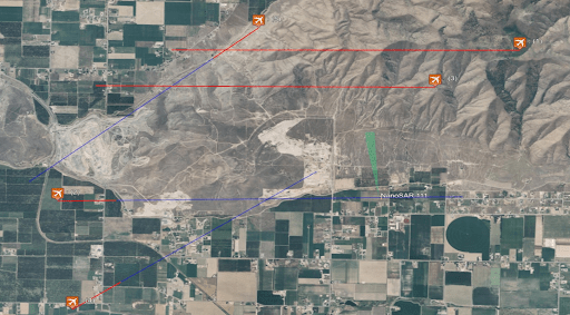
The angle, direction, and location of the radar relative to the surfaces being imaged matter for different types of data collection products, so pilots will need flight plans as well as skills to fly the aircraft to collect the best data.
For some SAR data products these plans are a necessity. For example, for a SAR sensor to collect CCD data, the sensor must image the same area at least twice from the same geometry using the same collection parameters. When mission specialists follow this procedure, the system can use data “pairs” to identify what has changed. Since change detection imagery requires precise positioning of the sensor while it is imaging the area, creating predetermined flight plans to match the parameters of each mission is essential.
The flight plan consists of predetermined flight “tracks” that the aircraft must follow. For best results, the platform should minimize deviations from the flight track for each collection pass.
Operators need to be familiar with the capabilities of their mission management software before they begin a data collection. Some data collection tasks can be automatically performed by the software, but a radar operator will need to perform other tasks. Practicing tasks through simulations will help prepare operators for future collections.
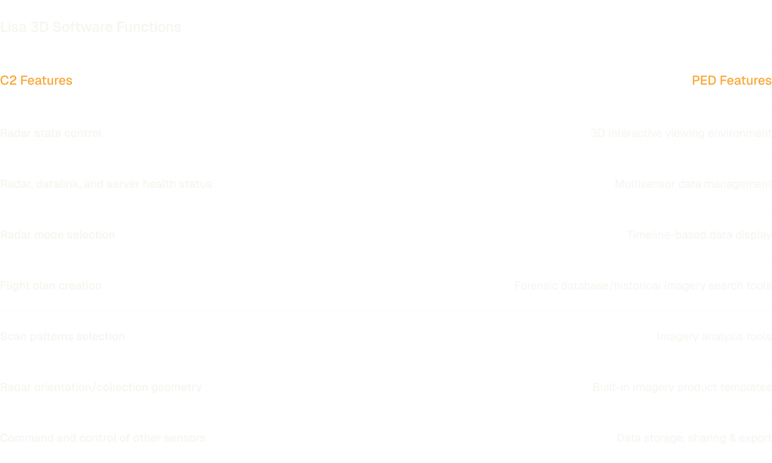
Mission management software can have Command and Control (C2) functionality, Processing, Exploitation, and Dissemination (PED) functionality, or both. IMSAR’s mission management software, Lisa 3D, performs both C2 and PED functions:
In addition to using predetermined flight plans, radar operators also have the option to use auto-collect modes in Lisa 3D, which enables the radar to collect data over a designated area without a predetermined flight plan as long as the path is within the radar’s field of regard. Operators can choose the following collection modes within Auto-Collect:
The Visual Guidance feature of Lisa 3D assists in flight accuracy during data collection by providing the pilot or unmanned platform operator with a real-time display of the radar’s relative position to the overall flight plan and the currently-selected flight leg. When collecting data according to a predetermined flight track, the goal is to fly as close as possible to the desired flight path with minimum roll, pitch, and crab. The Visual Guidance Plugin also features “vectoring”, which assists pilots in keeping a target in the radar’s field of regard during auto-collect missions. The purpose of vectoring in Visual Guidance is to provide the operator or pilot a real-time display of where the radar is supposed to be flown.
Mission specialists armed with a thorough pre-mission analysis, a flight plan, and a basic understanding of radar geometry and their equipment’s capabilities are set up for success to collect valuable and timely intelligence with radar.
For more information on the general capabilities of Lisa 3D and IMSAR’s radar control API, see Taking Advantage of Mission Management Software.
The training sessions included with every radar purchase provide customers with more details on collection planning. For more information about IMSAR radars, contact us at sales@imsar.com.

.png)